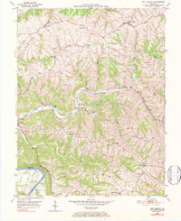
1950 Map of New Liberty
USGS Topo · Published 1984About this map
Wheatley and New Liberty center this 1950 topographical survey of the north-central Kentucky uplands, where the landscape is defined by the winding drainages of Little Twin Creek and Big Twin Creek. The map reveals a deeply entrenched rural settlement pattern, where small communities like Squiresville and Pleasant Home are connected by narrow ridge-top roads and the Citizens Pike. Along the southwestern edge, the Kentucky River carves a sharp boundary between Owen and Henry counties, with Perry Park situated near the riverbanks.
Find a feature on this map
43 named features on this map. Tap any name to fly to it.
Don’t see what you’re looking for? This feature index may not catch every label — zoom into the map to look around manually.
Map Details
Editions of this 1950 New Liberty Map
4 editions found
Other maps of this area

1906 · Lockport
USGS Topo · 1:48,000

1908 · Lockport
USGS Topo · 1:62,500

1928 · New Castle
USGS Topo · 1:48,000

1932 · New Castle
USGS Topo · 1:62,500

1943 · Vevay South
USGS Topo · 1:24,000

1950 · New Liberty
USGS Topo · 1:24,000

1950 · Glencoe
USGS Topo · 1:24,000

1950 · Owenton
USGS Topo · 1:24,000

1951 · Sanders
USGS Topo · 1:24,000

1952 · Vevay South
USGS Topo · 1:24,000