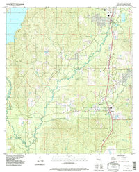
1994 Map of New Llano
USGS Topo · Published 1997About this map
The settlement of New Llano and its southern neighbor Pickering dominate the eastern edge of this Vernon Parish landscape. This mid-1990s survey illustrates a rural community pattern defined by numerous family burial grounds, including Gill Cem, Mt Pleasant Cem, and Wilson Cem, which anchor the various townships and unincorporated areas. The western portion of the map is defined by the winding waters of Bayou Anacoco and the expansive Anacoco Lake, providing a distinct contrast to the higher ground of Billy Goat Hill. Between these water bodies and the highway corridor lies a network of creeks and small settlements like Elmwood, where mobile home parks and scattered homesteads sit among the drainages of Bayou Castor and Bayou Zourie.
Find a feature on this map
21 named features on this map. Tap any name to fly to it.
Don’t see what you’re looking for? This feature index may not catch every label — zoom into the map to look around manually.
Map Details
Editions of this 1994 New Llano Map
This is the sole edition of this map. No revisions or reprints were ever made.
Other maps of this area

1941 · Leesville
USGS Topo · 1:62,500

1941 · Slagle
USGS Topo · 1:62,500

1943 · Leesville
USGS Topo · 1:62,500

1944 · Slagle
USGS Topo · 1:62,500

1946 · Leesville
USGS Topo · 1:62,500

1947 · Rosepine
USGS Topo · 1:31,680

1947 · Knight
USGS Topo · 1:31,680

1947 · Chasmore
USGS Topo · 1:31,680

1948 · Leesville
USGS Topo · 1:62,500

1952 · Lake Charles
USGS Topo · 1:250,000