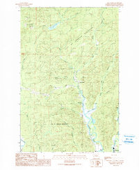
1990 Map of New London
USGS Topo · Published 1990About this map
New London sits at the confluence of several vital waterways in this Grays Harbor County survey, where the West Fork Hoquiam River meets the main stem of the Hoquiam River. This landscape is defined by its industrial and municipal utility, containing the extensive City of Hoquiam Watershed and the Hoquiam Water Works. The terrain is marked by numerous resource extraction sites, including several Borrow Pits and the Hoover Borrow Pit, alongside a Quarry near Deep Creek.
Find a feature on this map
29 named features on this map. Tap any name to fly to it.
Don’t see what you’re looking for? This feature index may not catch every label — zoom into the map to look around manually.
Map Details
Editions of this 1990 New London Map
This is the sole edition of this map. No revisions or reprints were ever made.
Other maps of this area

1938 · Moclips
USGS Topo · 1:62,500

1941 · Moclips
USGS Topo · 1:62,500

1941 · Grayland
USGS Topo · 1:62,500

1943 · Humptulips
USGS Topo · 1:62,500

1943 · Copalis Beach
USGS Topo · 1:250,000

1951 · Copalis Beach
USGS Topo · 1:250,000

1953 · Hoquiam
USGS Topo · 1:250,000

1955 · Humptulips
USGS Topo · 1:62,500

1955 · Carlisle
USGS Topo · 1:24,000

1956 · Copalis Crossing
USGS Topo · 1:24,000