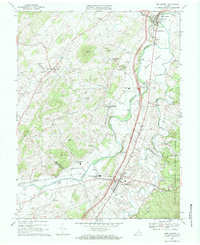
1967 Map of New Market
USGS Topo · Published 1968About this map
The North Fork Shenandoah River winds through the heart of this valley landscape, tracing a path past established settlements like Mt Jackson, New Market, and Quicksburg. The 1960s infrastructure is clearly visible, with Interchange 68 and Interchange 67 marking the modernization of the valley corridor alongside the historic Southern railroad line. Local history is deeply etched into the terrain at Meems Bottom and along the slopes of Rudes Hill, while educational and religious anchors such as Shenandoah Valley Academy, the Triplett Institute, and numerous country churches like St Marks Ch define the community's social geography. The map also highlights industrial and recreational sites, ranging from the Quarry near the Shenandoah River to the iconic Shenandoah Caverns and the Covered Bridge north of Quicksburg.
Find a feature on this map
55 named features on this map. Tap any name to fly to it.
Don’t see what you’re looking for? This feature index may not catch every label — zoom into the map to look around manually.
Map Details
Editions of this 1967 New Market Map
Other maps of this area

1892 · Woodstock
USGS Topo · 1:125,000

1921 · Orkney Springs
USGS Topo · 1:48,000

1923 · Orkney Springs
USGS Topo · 1:62,500

1923 · Edinburg
USGS Topo · 1:62,500

1940 · Orkney Springs
USGS Topo · 1:48,000

1942 · Mt Jackson
USGS Topo · 1:62,500

1943 · Orkney Springs
USGS Topo · 1:62,500

1944 · Orkney Springs
USGS Topo · 1:62,500

1946 · Mt Jackson
USGS Topo · 1:62,500

1947 · Mt Jackson
USGS Topo · 1:62,500