
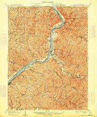
1906 Map of New Martinsville
USGS Topo · Published 1906About this map
Sistersville and Paden City anchor the West Virginia side of the Ohio River in this early twentieth-century survey, a period when the river served as the primary industrial and transport artery for the region. The Baltimore and Ohio railroad tracks trace the eastern shoreline, connecting riverfront hubs like Brooklyn and Steelton to the broader regional economy. Across the water in Ohio, smaller settlements such as Hannibal and Sardis overlook the river islands of Paden Island and Witten Towhead.
Find a feature on this map
127 named features on this map. Tap any name to fly to it.
Don’t see what you’re looking for? This feature index may not catch every label — zoom into the map to look around manually.
Map Details
Editions of this 1906 New Martinsville Map
2 editions found
Other maps of this area

1903 · Littleton
USGS Topo · 1:62,500

1904 · Cameron
USGS Topo · 1:62,500

1905 · Centerpoint
USGS Topo · 1:62,500

1905 · West Union
USGS Topo · 1:62,500

1905 · Littleton
USGS Topo · 1:62,500

1905 · Clarington
USGS Topo · 1:62,500

1905 · New Matamoras
USGS Topo · 1:62,500

1905 · Woodsfield
USGS Topo · 1:62,500

1906 · Saint Marys
USGS Topo · 1:62,500

1924 · St Marys
USGS Topo · 1:62,500