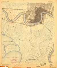
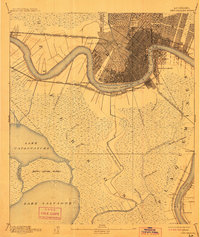
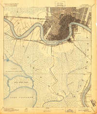
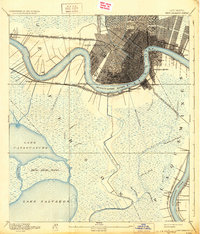
1891 Map of New Orleans
USGS Topo · Published 1898About this map
The Mississippi River defines the landscape of this late nineteenth-century survey, its serpentine curves anchoring the dense urban grid of New Orleans and its surrounding riverbank settlements. While the city's heart is tightly developed around City Park, the map reveals the critical rail and water infrastructure of the era, including the Harvey's Canal and La Branche Canal that facilitated trade through the wetlands. Beyond the city limits, small river outposts like Gretna, Macdonoughville, and Algiers serve as vital transit hubs.
Find a feature on this map
47 named features on this map. Tap any name to fly to it.
Don’t see what you’re looking for? This feature index may not catch every label — zoom into the map to look around manually.
Map Details
Editions of this 1891 New Orleans Map
5 editions found
Other maps of this area

1891 · Hahnville
USGS Topo · 1:62,500

1891 · Spanish Fort
USGS Topo · 1:62,500

1891 · Pointe a La Hache
USGS Topo · 1:62,500

1891 · New Orleans
USGS Topo · 1:62,500

1892 · Barataria
USGS Topo · 1:62,500

1892 · Chef Menteur
USGS Topo · 1:62,500

1892 · Bonnet Carre
USGS Topo · 1:62,500

1892 · Cut-Off
USGS Topo · 1:62,500

1892 · St. Bernard
USGS Topo · 1:62,500

1892 · Pointe a La Hache
USGS Topo · 1:62,500