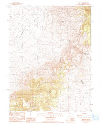
1990 Map of New Pass
USGS Topo · Published 1990About this map
The New Pass Range and Desatoya Mountains define the high-desert landscape of this central Nevada corridor, where the historic New Pass cuts through the rocky divide. Traces of 19th-century transit are evident at the Overland Stage Station (Ruins), a remnant of the vital communication and travel network that preceded modern highways. This 1990 provisional edition, based on earlier 1960s photogrammetry and 1980s field checks, highlights the topographical transition between Edwards Creek Valley and Smith Creek Valley. The terrain is marked by numerous spring sources and a large-scale Gravel Pit, reflecting the ongoing utility of this desert pass. The boundary between Churchill and Lander Counties bisects the southern range, providing a precise reference for surveyors and land historians tracking the administrative lines of the Great Basin.
Find a feature on this map
10 named features on this map. Tap any name to fly to it.
Don’t see what you’re looking for? This feature index may not catch every label — zoom into the map to look around manually.
Map Details
Editions of this 1990 New Pass Map
This is the sole edition of this map. No revisions or reprints were ever made.
Other maps of this area

1955 · Millett
USGS Topo · 1:250,000

1959 · Millett
USGS Topo · 1:250,000

1966 · Edwards Creek Valley
USGS Topo · 1:62,500

1969 · Mount Airy
USGS Topo · 1:24,000

1969 · Mount Airy NW
USGS Topo · 1:24,000

1969 · Emigrant Peak
USGS Topo · 1:24,000

1969 · Carroll Summit NE
USGS Topo · 1:24,000

1969 · Basque Summit
USGS Topo · 1:24,000

1983 · Edwards Creek Valley
USGS Topo · 1:100,000

1985 · Smith Creek Valley
USGS Topo · 1:100,000