
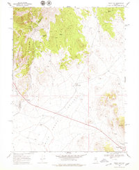
1969 Map of Mount Airy
USGS Topo · Published 1971About this map
New Pass Mine and several mining shafts mark the western heights of the New Pass Range in this late 1960s survey of the Nevada desert. The landscape is defined by the sharp transition from the steep peaks of the range down into the wide Smith Creek Valley, where Petersons Mill and a Spring (Hot) sit near the valley floor. This area straddles the Churchill Co and Lander Co border, showing a remote industrial and ranching environment dependent on scattered water sources like Barrel Spring and Indian Spring.
Find a feature on this map
20 named features on this map. Tap any name to fly to it.
Don’t see what you’re looking for? This feature index may not catch every label — zoom into the map to look around manually.
Map Details
Editions of this 1969 Mount Airy Map
2 editions found
Other maps of this area

1955 · Millett
USGS Topo · 1:250,000

1959 · Millett
USGS Topo · 1:250,000

1966 · Edwards Creek Valley
USGS Topo · 1:62,500

1969 · Mount Airy NW
USGS Topo · 1:24,000

1969 · Mount Airy NE
USGS Topo · 1:24,000

1969 · Gandolfo Canyon
USGS Topo · 1:24,000

1969 · Mount Airy Mesa
USGS Topo · 1:24,000

1969 · Emigrant Peak
USGS Topo · 1:24,000

1969 · Carroll Summit NE
USGS Topo · 1:24,000

1983 · Edwards Creek Valley
USGS Topo · 1:100,000