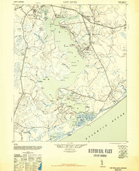
1948 Map of New River
USGS Topo · Published 1948About this map
Jacksonville and the surrounding coastal reaches of the New River are dominated by military installations and a network of water-based transport just after the Second World War. The landscape shows the significant footprint of the Marine Base Headquarters and the Marine Barracks, with specialized facilities like the Peters Point Field Glider Base illustrating the era's tactical aviation needs. Despite this military buildup at Camp Knox and Midway Park, older maritime patterns remain visible through numerous ferry crossings and landings. Sneads Ferry serves as a primary link across the river, while Hurst Ferry and Pollocks Point Ferry facilitate movement between the marshy peninsulas and bays. Industrial and residential remnants like Mumfords Mill and the Trailer Camp near Piney Green provide clues to the local economy and housing during this period of transition.
Find a feature on this map
95 named features on this map. Tap any name to fly to it.
Don’t see what you’re looking for? This feature index may not catch every label — zoom into the map to look around manually.
Map Details
Editions of this 1948 New River Map
2 editions found
Other maps of this area

1942 · Spicer Bay
USGS Topo · 1:62,500

1942 · Topsail
USGS Topo · 1:62,500

1942 · Maysville
USGS Topo · 1:62,500

1942 · Swansboro
USGS Topo · 1:62,500

1943 · Jacksonville
USGS Topo · 1:62,500

1948 · Maysville
USGS Topo · 1:62,500

1948 · Maple Hill
USGS Topo · 1:62,500

1948 · Swansboro
USGS Topo · 1:62,500

1948 · Topsail
USGS Topo · 1:62,500

1948 · New River
USGS Topo · 1:62,500