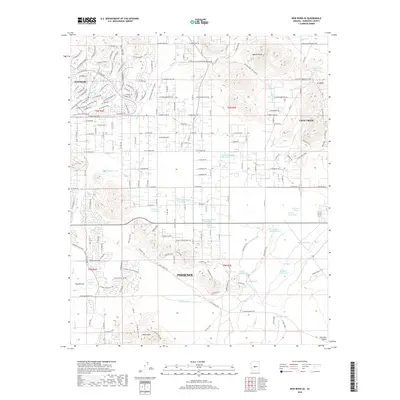
2018 Map of New River SE
USGS Topo · Published 2018About this map
The master-planned community of Anthem anchors the northwestern corner of this study, showcasing its intricate residential street network against the desert landscape. To the south, the northern reaches of Phoenix begin to unfurl near the Union Hills, while the western edge of Cave Creek is visible to the east. This 2018 survey illustrates the modern intersection of suburban expansion and a rugged hydrographic system defined by ephemeral washes and catchments. Water management is a primary theme of the terrain, with features like Purcell Tank, Mesquite Tank, and Desert Lake Tank distributed across the dry basins. The topography is dominated by dramatic rises such as Apache Peak and the high ground near Gunsight, which contrast with the level expanse of Biscuit Flat. Between these peaks, a network of seasonal drainages including Apache Wash, Deadman Wash, and Skunk Creek channel desert runoff, illustrating the natural drainage patterns that dictate regional development.
Find a feature on this map
127 named features on this map. Tap any name to fly to it.
Don’t see what you’re looking for? This feature index may not catch every label — zoom into the map to look around manually.
Map Details
Editions of this 2018 New River SE Map
This is the sole edition of this map. No revisions or reprints were ever made.
Other maps of this area

1904 · Camelback
USGS Topo · 1:62,500

1906 · Camelsback
USGS Topo · 1:62,500

1930 · Cave Creek
USGS Topo · 1:125,000

1939 · Cave Creek
USGS Topo · 1:125,000

1954 · Phoenix
USGS Topo · 1:250,000

1954 · Mesa
USGS Topo · 1:250,000

1957 · Mesa
USGS Topo · 1:250,000

1957 · Phoenix
USGS Topo · 1:250,000

1957 · Hedgpeth Hills
USGS Topo · 1:24,000

1958 · Mesa
USGS Topo · 1:250,000