
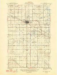
1948 Map of New Rockford
USGS Topo · Published 1948About this map
New Rockford serves as the focal point of this late 1940s survey, situated where the Northern Pacific railroad lines intersect in central North Dakota. The landscape is a study in early mid-century prairie development, featuring a dense network of country schools like Rockford Consolidated Sch and Estabrook Sch that supported the surrounding agricultural townships of Munster, Rosefield, and Estabrook. The winding course of the James River and Rocky Run cut through the terrain, while the local infrastructure includes the New Rockford Airfield and the New Rockford Country Club. Further south, the settlement of Barlow is noted alongside the Barlow Cem, providing a detailed look at the community structure of Eddy and Foster counties during this era.
Find a feature on this map
28 named features on this map. Tap any name to fly to it.
Don’t see what you’re looking for? This feature index may not catch every label — zoom into the map to look around manually.
Map Details
Editions of this 1948 New Rockford Map
2 editions found
Other maps of this area

1900 · Pingree
USGS Topo · 1:125,000

1928 · Tokio
USGS Topo · 1:62,500

1931 · Oberon
USGS Topo · 1:62,500

1931 · Tokio
USGS Topo · 1:62,500

1932 · Flora
USGS Topo · 1:62,500

1944 · Brantford
USGS Topo · 1:62,500

1946 · Brantford
USGS Topo · 1:62,500

1948 · Cathay
USGS Topo · 1:62,500

1948 · Carrington
USGS Topo · 1:62,500

1949 · Cathay SE
USGS Topo · 1:24,000