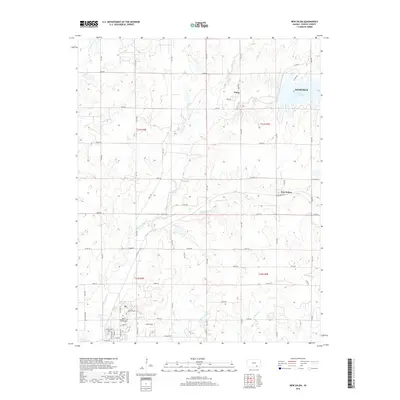
2018 Map of New Salem
USGS Topo · Published 2018About this map
Winfield serves as the primary hub on this map, showing its eastern expansion toward the waters of Timber Creek Lake. The landscape is defined by the dendritic drainage patterns of Timber Creek and its many tributaries, including Dutch Creek and Cedar Creek, which carve through the agricultural sections of the Flint Hills region. The map reveals a transition from the structured residential and public spaces of the city—such as Davis Field and the Union Cem—to the quieter rural communities of New Salem and Floral. A notable inclusion is the Kansas Veterans Cem at Winfield, which highlights the area's role as a regional center for veterans and public service. The intricate network of section-line roads, such as 102nd Rd and 131st Rd, underscores the enduring presence of the Public Land Survey System in defining the rural Kansas economy.
Find a feature on this map
55 named features on this map. Tap any name to fly to it.
Don’t see what you’re looking for? This feature index may not catch every label — zoom into the map to look around manually.
Map Details
Editions of this 2018 New Salem Map
This is the sole edition of this map. No revisions or reprints were ever made.
Other maps of this area

1889 · Burden
USGS Topo · 1:125,000

1890 · Wellington
USGS Topo · 1:125,000

1955 · Udall
USGS Topo · 1:24,000

1955 · Wichita
USGS Topo · 1:250,000

1958 · Wichita
USGS Topo · 1:250,000

1964 · Burden
USGS Topo · 1:24,000
1964 · Atlanta
USGS Topo · 1:24,000

1965 · Eaton
USGS Topo · 1:24,000

1965 · Winfield
USGS Topo · 1:24,000
1965 · Wilmot
USGS Topo · 1:24,000