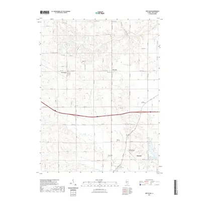
2021 Map of New Salem
USGS Topo · Published 2021About this map
The agrarian landscape of Pike County unfolds between the upper reaches of S Fork McKee Cr and the northern edge of Pittsfield. This region is defined by its small crossroads settlements, notably New Salem and Maysville, which serve as anchors for a grid of rural routes like Baylis Rd and Maysville Rd. For genealogists, the map is remarkably dense with family-named burial sites, including the Hinman Cem, Swiggett Cem, and the compound-named Moore - Enderly - Yackley Cem. The southern portion of the quadrangle shows the modernization of the area with the Pittsfield Penstone Municipal Airport and the recreational waters of Lake Pittsfield. Tributaries such as Blue Cr and Panther Cr carve through the terrain, illustrating the drainage patterns that have historically shaped local farm boundaries and road placements.
Find a feature on this map
87 named features on this map. Tap any name to fly to it.
Don’t see what you’re looking for? This feature index may not catch every label — zoom into the map to look around manually.
Map Details
Editions of this 2021 New Salem Map
This is the sole edition of this map. No revisions or reprints were ever made.
Other maps of this area

1924 · Griggsville
USGS Topo · 1:62,500

1926 · Griggsville
USGS Topo · 1:62,500

1926 · Pittsfield
USGS Topo · 1:62,500

1926 · Mt Sterling
USGS Topo · 1:62,500

1928 · Meredosia
USGS Topo · 1:62,500

1929 · Mt Sterling
USGS Topo · 1:62,500

1931 · Meredosia
USGS Topo · 1:62,500

1948 · Quincy
USGS Topo · 1:250,000

1956 · Quincy
USGS Topo · 1:250,000
1975 · Pittsfield SE
USGS Topo · 1:24,000