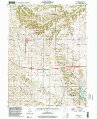
1998 Map of New Salem
USGS Topo · Published 2001About this map
The rural landscape of northern Pike County is defined by the winding course of McKee Creek and its South Fork McKee Creek, carving through the townships of New Salem and Griggsville. By the late 1990s, the area's development shows a mix of traditional agriculture and modern infrastructure, centered around the village of New Salem and the transit corridors of Interchange 31 and Interchange 35. A sprawling Gas Field in the northwest corner indicates the region's energy resources, while family-named burial grounds like Staggett Cem and Hinman Cem preserve the genealogy of early settlers.
Find a feature on this map
29 named features on this map. Tap any name to fly to it.
Don’t see what you’re looking for? This feature index may not catch every label — zoom into the map to look around manually.
Map Details
Editions of this 1998 New Salem Map
This is the sole edition of this map. No revisions or reprints were ever made.
Other maps of this area

1924 · Griggsville
USGS Topo · 1:62,500

1926 · Griggsville
USGS Topo · 1:62,500

1926 · Pittsfield
USGS Topo · 1:62,500

1926 · Mt Sterling
USGS Topo · 1:62,500

1928 · Meredosia
USGS Topo · 1:62,500

1929 · Mt Sterling
USGS Topo · 1:62,500

1931 · Meredosia
USGS Topo · 1:62,500

1948 · Quincy
USGS Topo · 1:250,000

1956 · Quincy
USGS Topo · 1:250,000
1975 · Pittsfield SE
USGS Topo · 1:24,000