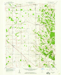
1959 Map of New Salem
USGS Topo · Published 1973About this map
The agrarian landscape of southeastern Rush County comes into focus through this 1959 survey, where the Baltimore and Ohio railroad cuts a diagonal path through Farmington and Mauzy in the north. This region is defined by its transition from the level till plains of Union and Noble townships into the dissected drainage basins of Garrison Creek and Sanes Creek to the east. The map documents a dense network of local institutions, including the Old Friends Ch Cem and the Little Flatrock Ch, reflecting the deep-rooted settlement patterns of the mid-20th century.
Find a feature on this map
37 named features on this map. Tap any name to fly to it.
Don’t see what you’re looking for? This feature index may not catch every label — zoom into the map to look around manually.
Map Details
Editions of this 1959 New Salem Map
Other maps of this area

1953 · Cincinnati
USGS Topo · 1:250,000

1956 · Alpine
USGS Topo · 1:24,000

1956 · Metamora
USGS Topo · 1:24,000

1956 · Connersville
USGS Topo · 1:24,000

1957 · Cincinnati
USGS Topo · 1:250,000

1958 · Clarksburg
USGS Topo · 1:24,000

1959 · Milroy
USGS Topo · 1:24,000

1959 · Rushville
USGS Topo · 1:24,000

1959 · New Salem
USGS Topo · 1:24,000

1959 · Mays
USGS Topo · 1:24,000