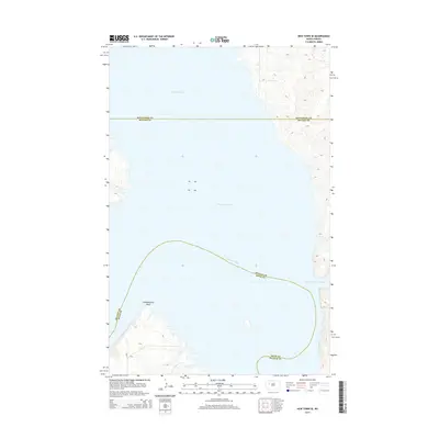
2014 Map of New Town SE
USGS Topo · Published 2014About this map
Lake Sakakawea dominates the landscape of this region, where the inundated valley of the Missouri River creates a complex shoreline of deep bays and prominent points. The waters of the Van Hook Arm stretch across the northern reaches, while the southeastern corner is defined by Lucky Mound Creek Bay. This topography is a result of the mid-20th-century damming of the river, which transformed the prairie river bottom into a massive reservoir. Along the southwestern shore, Independence Point stands as a significant landmark above the waterline. The map also delineates the meeting of three counties—Mountrail, McLean, and Dunn—with their boundaries largely following the submerged channel of the old river. Transportation is limited to local routes such as Bia-13, which serves the high ground above the reservoir's reach.
Find a feature on this map
9 named features on this map. Tap any name to fly to it.
Don’t see what you’re looking for? This feature index may not catch every label — zoom into the map to look around manually.
Map Details
Editions of this 2014 New Town SE Map
This is the sole edition of this map. No revisions or reprints were ever made.
Other maps of this area

1953 · Watford City
USGS Topo · 1:250,000

1957 · Watford City
USGS Topo · 1:250,000

1967 · Watford City
USGS Topo · 1:250,000

1967 · Raub NW
USGS Topo · 1:24,000

1967 · New Town SW
USGS Topo · 1:24,000

1967 · Parshall SW
USGS Topo · 1:24,000

1967 · New Town SE
USGS Topo · 1:24,000

1970 · String Buttes
USGS Topo · 1:24,000
1970 · Saddle Butte
USGS Topo · 1:24,000

1981 · New Town
USGS Topo · 1:24,000