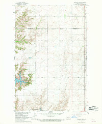
1967 Map of Parshall SW
USGS Topo · Published 1970About this map
Lake Sakakawea dominates the western and southern landscape of this 1967 survey, its shoreline defining the contours of Lucky Mound Creek Bay. The map reveals a transitional period for the Missouri River Basin, documenting the reservoir at a normal pool elevation of 1838 feet. Stretching across the north, the Fort Berthold Indian Reservation Boundary separates the tribal lands from the townships of Fertile and Banner. Evidence of local governance and land management is visible through the small Townhall in the north and the Deepwater Creek State Game Management Area along the southern water's edge. The rugged breaks leading down to the water contrast with the organized grid of section lines that define the agricultural uplands of Loquemont in the southeast.
Find a feature on this map
15 named features on this map. Tap any name to fly to it.
Don’t see what you’re looking for? This feature index may not catch every label — zoom into the map to look around manually.
Map Details
Editions of this 1967 Parshall SW Map
2 editions found

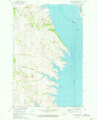
Other maps of this area

1953 · Watford City
USGS Topo · 1:250,000

1957 · Watford City
USGS Topo · 1:250,000

1967 · Watford City
USGS Topo · 1:250,000

1967 · Raub NW
USGS Topo · 1:24,000

1967 · Raub
USGS Topo · 1:24,000

1967 · Parshall SE
USGS Topo · 1:24,000

1967 · New Town SE
USGS Topo · 1:24,000
1970 · Saddle Butte
USGS Topo · 1:24,000
1981 · Parshall NE
USGS Topo · 1:24,000
1981 · Parshall
USGS Topo · 1:24,000