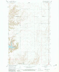
1967 Map of Parshall SW
USGS Topo · Published 1982About this map
Lake Sakakawea dominates the southwestern corner of this landscape, its waters reaching into the rugged breaks of Lucky Mound Creek Bay. Surveyed in the late 1960s, the map illustrates the dramatic transformation of the Missouri River valley into a massive reservoir system, where the pool elevation is recorded at 1,838 feet. Along the shoreline, the Deepwater Creek State Game Management Area preserves the transitional habitat between the water and the upland prairies.
Find a feature on this map
11 named features on this map. Tap any name to fly to it.
Don’t see what you’re looking for? This feature index may not catch every label — zoom into the map to look around manually.
Map Details
Editions of this 1967 Parshall SW Map
2 editions found
Other maps of this area

1953 · Watford City
USGS Topo · 1:250,000

1957 · Watford City
USGS Topo · 1:250,000

1967 · Watford City
USGS Topo · 1:250,000

1967 · Raub NW
USGS Topo · 1:24,000

1967 · Raub
USGS Topo · 1:24,000
1967 · Parshall SE
USGS Topo · 1:24,000

1967 · Parshall SW
USGS Topo · 1:24,000

1967 · New Town SE
USGS Topo · 1:24,000
1970 · Saddle Butte
USGS Topo · 1:24,000
1981 · Parshall NE
USGS Topo · 1:24,000