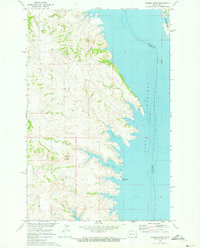
1970 Map of Saddle Butte
USGS Topo · Published 1973About this map
Lake Sakakawea dominates the eastern landscape of this quadrangle, its waters held at an elevation of 1838 feet where the Missouri River has been transformed by mid-century engineering. The shoreline is characterized by complex inlets and fingers of water, including Saddle Butte Bay and Mckenzie Bay, which cut into the rising bluffs of the Fort Berthold Indian Reservation. On higher ground, the namesake Saddle Butte rises above the breaks, serving as a prominent topographical landmark in a region defined by the transition from prairie to reservoir. This 1970 field-checked survey reveals the area's dual nature as both a managed waterway and a conservation landscape, marked by the State Game Management Area in the northeast and the Saddle Butte Public Use Area along the southern shore. The boundary between McLean and Dunn counties follows the old river channel, now submerged beneath the lake.
Find a feature on this map
7 named features on this map. Tap any name to fly to it.
Don’t see what you’re looking for? This feature index may not catch every label — zoom into the map to look around manually.
Map Details
Editions of this 1970 Saddle Butte Map
This is the sole edition of this map. No revisions or reprints were ever made.
Other maps of this area

1953 · Watford City
USGS Topo · 1:250,000

1957 · Watford City
USGS Topo · 1:250,000

1967 · Watford City
USGS Topo · 1:250,000

1967 · Raub NW
USGS Topo · 1:24,000

1967 · Twin Buttes
USGS Topo · 1:24,000

1967 · New Town SW
USGS Topo · 1:24,000

1967 · Parshall SW
USGS Topo · 1:24,000

1967 · New Town SE
USGS Topo · 1:24,000

1970 · Hay Flat
USGS Topo · 1:24,000

1970 · String Buttes
USGS Topo · 1:24,000