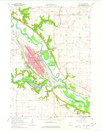
1964 Map of New Ulm
USGS Topo · Published 1978About this map
New Ulm serves as the focal point of this mid-1960s survey, situated at the confluence of the Minnesota River and the Cottonwood River. The town's grid is dense with institutions like Cathedral High Sch, Martin Luther College, and Loretto Hospital, reflecting its role as a regional educational and medical hub. The Chicago and North Western railroad corridors parallel the river valley, facilitating the movement of goods through the agricultural landscape. To the south, Flandrau State Park surrounds Lake Cottonwood, providing a preserved natural break from the industrial and residential development of the city. Beyond the main settlement, the rural landscape of Lafayette and Courtland is dotted with gravel pits and local landmarks such as Klossner and the St Josephs Cem, illustrating the 20th-century transition between developed town life and the surrounding farm economy.
Find a feature on this map
40 named features on this map. Tap any name to fly to it.
Don’t see what you’re looking for? This feature index may not catch every label — zoom into the map to look around manually.
Map Details
Editions of this 1964 New Ulm Map
2 editions found
Other maps of this area

1953 · New Ulm
USGS Topo · 1:250,000

1957 · New Ulm
USGS Topo · 1:250,000

1958 · New Ulm
USGS Topo · 1:250,000

1964 · Bernadotte
USGS Topo · 1:24,000

1964 · New Ulm
USGS Topo · 1:24,000

1964 · Courtland
USGS Topo · 1:24,000

1964 · Essig
USGS Topo · 1:24,000

1964 · Lafayette
USGS Topo · 1:24,000

1964 · St George
USGS Topo · 1:24,000

1965 · Hanska
USGS Topo · 1:24,000