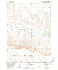
1953 Map of New Underwood NW
USGS Topo · Published 1981About this map
Elk Creek meanders through this South Dakota landscape, defining the local drainage patterns as they appeared in the early 1950s. The terrain is marked by the winding courses of Antelope Cr and its tributaries, showing a sparse rural development typical of the western plains during this era. A single center of community life, Brehm Sch, stands north of the main creek, serving as a vital landmark for local history and genealogy. The map also delineates the administrative boundary of Meade Co Pennington Co, providing a clear record of the jurisdictional divide between these two counties as documented by the Geological Survey. This 1953 field-checked study offers a precise view of the topography before later shifts in regional infrastructure.
Find a feature on this map
4 named features on this map. Tap any name to fly to it.
Don’t see what you’re looking for? This feature index may not catch every label — zoom into the map to look around manually.
Map Details
Editions of this 1953 New Underwood NW Map
2 editions found
Other maps of this area

1893 · Rapid
USGS Topo · 1:125,000

1898 · Rapid
USGS Topo · 1:125,000

1903 · Rapid
USGS Topo · 1:125,000

1953 · Bend
USGS Topo · 1:24,000

1953 · Viewfield
USGS Topo · 1:24,000

1953 · Hereford SE
USGS Topo · 1:24,000

1953 · Boxelder
USGS Topo · 1:24,000

1953 · New Underwood
USGS Topo · 1:24,000

1953 · New Underwood SW
USGS Topo · 1:24,000

1953 · Hereford SW
USGS Topo · 1:24,000