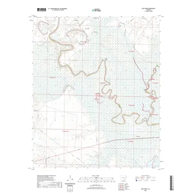
2020 Map of New Union
USGS Topo · Published 2020About this map
The Ouachita River winds through a complex system of oxbows and bottomland swamps at the convergence of Union, Bradley, and Ashley counties. This low-lying riverine landscape is defined by its dramatic meanders, creating distinctive features such as Caney Marais Bend and Staveyard Bend. Local hydrology is dominated by numerous secondary water bodies including Mud Lake, Straight Lake, and Bend Lake, which suggest the river's historical shifting course. Higher ground is identified by ridges and "islands" rising out of the wetlands, notably Oak Ridge, Pea Ridge, and Pine Island. The map shows a landscape primarily shaped by its natural drainage patterns, with smaller tributaries like Lapoile Cr and South Lapile Creek feeding the larger river system. While largely characterized by its marshes and brakes like Boeuf Brake, the area is accessible by a network of rural roads such as Jones Lake Rd and North Rd.
Find a feature on this map
42 named features on this map. Tap any name to fly to it.
Don’t see what you’re looking for? This feature index may not catch every label — zoom into the map to look around manually.
Map Details
Editions of this 2020 New Union Map
This is the sole edition of this map. No revisions or reprints were ever made.
Other maps of this area

1933 · Strong
USGS Topo · 1:62,500

1934 · Ingalls
USGS Topo · 1:48,000

1934 · Felsenthal
USGS Topo · 1:62,500

1934 · Moro Bay
USGS Topo · 1:62,500

1937 · Strong
USGS Topo · 1:62,500

1937 · Felsenthal
USGS Topo · 1:62,500

1937 · Ingalls
USGS Topo · 1:62,500

1938 · Felsenthal
USGS Topo · 1:62,500

1938 · Moro Bay
USGS Topo · 1:62,500

1939 · Felsenthal
USGS Topo · 1:62,500