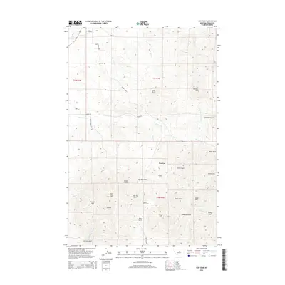
2014 Map of New Year
USGS Topo · Published 2014About this map
New Year sits at the heart of the Judith Mountains in Fergus County, surrounded by a complex network of canyons and gulches that defined this Montana mining and ranching district. The landscape is characterized by high summits including New Year Peak, Burnette Peak, and Pyramid Peak, with drainage systems like Ruby Gulch and Dexter Gulch carving through the mountain terrain. Historically significant locations for genealogists include Trout Creek Cem and Hilger Cem, which serve as quiet markers of the early families who settled near the upper reaches of Warm Spring Cr. The area is accessible via several historic routes such as Maiden Rd and the Maiden Cutoff, reflecting the connection between this settlement and nearby mining camps. Natural landmarks like Devils Canyon and Limekiln Canyon highlight the steep relief of the Judith range, where water sources like Moccasin Cr and Fish Cr originate.
Find a feature on this map
40 named features on this map. Tap any name to fly to it.
Don’t see what you’re looking for? This feature index may not catch every label — zoom into the map to look around manually.
Map Details
Editions of this 2014 New Year Map
This is the sole edition of this map. No revisions or reprints were ever made.
Other maps of this area

1941 · Lewistown
USGS Topo · 1:62,500

1941 · Judith Peak
USGS Topo · 1:62,500

1944 · Lewistown
USGS Topo · 1:62,500

1944 · Judith Peak
USGS Topo · 1:62,500

1954 · Lewistown
USGS Topo · 1:250,000

1959 · Lewistown
USGS Topo · 1:250,000

1978 · Lewistown
USGS Topo · 1:100,000
1985 · Kendall
USGS Topo · 1:24,000

1985 · Hilger
USGS Topo · 1:24,000

1985 · Armells
USGS Topo · 1:24,000