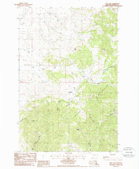
1985 Map of New Year
USGS Topo · Published 1986About this map
The Judith Mountains dominate this 1980s landscape, a region deeply marked by its mining history and the rugged drainage patterns of Fergus County. The settlement of New Year sits at the heart of a complex network of gulches and peaks, including New Year Gulch and New Year Peak. Evidence of historic transport and industrial activity is scattered across the terrain, from the Old RR Grade winding through the northern sections to numerous Prospect and Mine Shaft locations. The map illustrates a transitional era where traditional ranching and mining infrastructure, such as the Lucier Ranch Landing Strip, coexist with modern utility developments like the Sewage Treatment Plant near Warm Spring Creek. Notable landmarks like Porphyry Peak and Burnette Peak anchor the topography, while deep cuts like Devils Canyon and Whisky Gl define the southeastern slopes.
Find a feature on this map
32 named features on this map. Tap any name to fly to it.
Don’t see what you’re looking for? This feature index may not catch every label — zoom into the map to look around manually.
Map Details
Editions of this 1985 New Year Map
This is the sole edition of this map. No revisions or reprints were ever made.
Other maps of this area

1941 · Lewistown
USGS Topo · 1:62,500

1941 · Judith Peak
USGS Topo · 1:62,500

1944 · Lewistown
USGS Topo · 1:62,500

1944 · Judith Peak
USGS Topo · 1:62,500

1954 · Lewistown
USGS Topo · 1:250,000

1959 · Lewistown
USGS Topo · 1:250,000

1978 · Lewistown
USGS Topo · 1:100,000
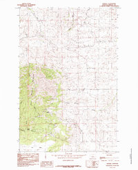
1985 · Kendall
USGS Topo · 1:24,000

1985 · Hilger
USGS Topo · 1:24,000

1985 · Armells
USGS Topo · 1:24,000