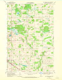
1969 Map of New York Mills East
USGS Topo · Published 1971About this map
New York Mills anchors the southwestern corner of this survey, appearing just as the Burlington Northern railroad corridor was established through the region. The landscape is defined by the winding course of Bluff Creek, which flows southeast toward the township of Bluffton. To the north, the Bluff Creek State Wildlife Management Area preserves a significant portion of the wetland-rich terrain typical of Otter Tail County. The transition from agricultural use to conservation is evident in the townships of Homestead, Newton, and Blowers, which are marked by a complex network of marshes and small lakes. Aviation infrastructure is noted at the New York Mills Municipal Airport, while the tiny settlement of Davies and a lone Gravel Pit represent the smaller footprints of local community and industry during the late 1960s.
Find a feature on this map
14 named features on this map. Tap any name to fly to it.
Don’t see what you’re looking for? This feature index may not catch every label — zoom into the map to look around manually.
Map Details
Editions of this 1969 New York Mills East Map
This is the sole edition of this map. No revisions or reprints were ever made.
Other maps of this area

1953 · Brainerd
USGS Topo · 1:250,000

1957 · Brainerd
USGS Topo · 1:250,000

1958 · Brainerd
USGS Topo · 1:250,000

1965 · Brainerd
USGS Topo · 1:250,000

1969 · Sebeka SW
USGS Topo · 1:24,000

1969 · New York Mills NW
USGS Topo · 1:24,000

1969 · Sebeka NW
USGS Topo · 1:24,000

1969 · Heinola
USGS Topo · 1:24,000

1969 · New York Mills West
USGS Topo · 1:24,000

1969 · Wadena
USGS Topo · 1:24,000