
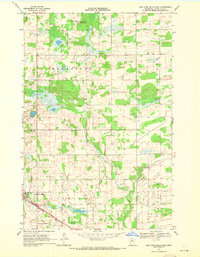
1969 Map of New York Mills NW
USGS Topo · Published 1971About this map
The Becker Co Otter Tail Co line divides this landscape of wetlands and lakes in the late 1960s, a region defined by its conservation areas and rural community hubs. Large tracts of land are preserved within the Perham State Wildlife Management Area and the Butler State Wildlife Management Area, surrounding significant water bodies like Edna Lake and Mud Lake. The presence of several Sandpits and a Gravel Pit indicates the local importance of aggregate extraction for road and infrastructure development in this glaciated terrain.
Find a feature on this map
23 named features on this map. Tap any name to fly to it.
Don’t see what you’re looking for? This feature index may not catch every label — zoom into the map to look around manually.
Map Details
Editions of this 1969 New York Mills NW Map
This is the sole edition of this map. No revisions or reprints were ever made.
Other maps of this area

1915 · Perham
USGS Topo · 1:62,500

1953 · Brainerd
USGS Topo · 1:250,000

1957 · Brainerd
USGS Topo · 1:250,000

1958 · Brainerd
USGS Topo · 1:250,000

1959 · Toad Mountain
USGS Topo · 1:24,000

1965 · Brainerd
USGS Topo · 1:250,000

1969 · Wolf Lake
USGS Topo · 1:24,000

1969 · Evergreen
USGS Topo · 1:24,000

1969 · New York Mills West
USGS Topo · 1:24,000
1969 · New York Mills East
USGS Topo · 1:24,000