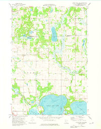
1973 Map of Little Pine Lake
USGS Topo · Published 1975About this map
Little Pine Lake and Big Pine Lake dominate the southern portion of this Otter Tail County landscape, where the Otter Tail River winds through marshy lowlands near Mud Lake. The 1973 survey reveals a glacial terrain defined by numerous smaller bodies of water like Dead Lake and Indian Lake, as well as the north-flowing Toad River. Settled patterns are evident in the township grids of Silver Leaf, Evergreen, and Gorman, connected by a network of section roads and the BN railroad line cutting across the southwest corner. For those tracing local families, the map identifies specific burial sites including Township Cem and Bauck Cem. The transition from the elevated Pine Ridge to the lake-studded plains reflects the complex post-glacial hydrology of the region before significant modern development.
Find a feature on this map
22 named features on this map. Tap any name to fly to it.
Don’t see what you’re looking for? This feature index may not catch every label — zoom into the map to look around manually.
Map Details
Editions of this 1973 Little Pine Lake Map
This is the sole edition of this map. No revisions or reprints were ever made.
Other maps of this area

1915 · Perham
USGS Topo · 1:62,500

1953 · Brainerd
USGS Topo · 1:250,000

1957 · Brainerd
USGS Topo · 1:250,000

1958 · Brainerd
USGS Topo · 1:250,000

1959 · Toad Mountain
USGS Topo · 1:24,000

1959 · Rochert
USGS Topo · 1:24,000

1965 · Brainerd
USGS Topo · 1:250,000

1969 · Evergreen
USGS Topo · 1:24,000

1969 · New York Mills NW
USGS Topo · 1:24,000

1969 · New York Mills West
USGS Topo · 1:24,000