
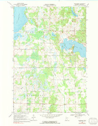
1969 Map of Evergreen
USGS Topo · Published 1971About this map
Toad Lake and Wolf Lake dominate this Becker County landscape, which transitions from the lake-studded north to the winding drainage of the Redeye River in the south. The small settlement of Evergreen is situated in the lower section of the map, serving as a local anchor point amidst the surrounding wetlands and woods. This 1969 field-checked survey reveals a rural community defined by its water bodies and local institutions, including Zion Ch and Pickerel Ch.
Find a feature on this map
19 named features on this map. Tap any name to fly to it.
Don’t see what you’re looking for? This feature index may not catch every label — zoom into the map to look around manually.
Map Details
Editions of this 1969 Evergreen Map
2 editions found
Other maps of this area

1915 · Perham
USGS Topo · 1:62,500

1953 · Brainerd
USGS Topo · 1:250,000

1957 · Brainerd
USGS Topo · 1:250,000

1958 · Brainerd
USGS Topo · 1:250,000

1959 · Toad Mountain
USGS Topo · 1:24,000

1959 · Height Of Land Lake
USGS Topo · 1:24,000

1965 · Brainerd
USGS Topo · 1:250,000

1969 · Wolf Lake
USGS Topo · 1:24,000

1969 · New York Mills NW
USGS Topo · 1:24,000
1969 · Ponsford
USGS Topo · 1:24,000