
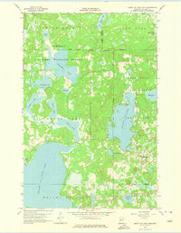
1959 Map of Height Of Land Lake
USGS Topo · Published 1960About this map
Tamarac National Wildlife Refuge and the Smoky Hills State Forest dominate this glaciated landscape in Becker County, defined by a dense network of lakes and waterways. The White Earth Indian Reservation Boundary cuts through the northern portion of the map, separating Sugar Bush from the protected wildlife areas. The massive Height of Land Lake sits at the center of a complex hydrologic system where the Otter Tail River connects smaller basins like Rice Lake and Chippewa Lake.
Find a feature on this map
34 named features on this map. Tap any name to fly to it.
Don’t see what you’re looking for? This feature index may not catch every label — zoom into the map to look around manually.
Map Details
Editions of this 1959 Height Of Land Lake Map
2 editions found
Other maps of this area

1953 · Brainerd
USGS Topo · 1:250,000

1954 · Bemidji
USGS Topo · 1:250,000

1957 · Brainerd
USGS Topo · 1:250,000

1957 · Bemidji
USGS Topo · 1:250,000

1958 · Bemidji
USGS Topo · 1:250,000

1958 · Brainerd
USGS Topo · 1:250,000

1959 · Toad Mountain
USGS Topo · 1:24,000

1959 · Flat Lake
USGS Topo · 1:24,000

1959 · Rochert
USGS Topo · 1:24,000

1965 · Brainerd
USGS Topo · 1:250,000