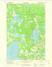
1959 Map of Height Of Land Lake
USGS Topo · Published 1975About this map
Tamarac National Wildlife Refuge and the Smoky Hills State Forest dominate this Becker County landscape, illustrating a region defined by conservation and Indigenous heritage in the late 1950s. The White Earth Indian Reservation Boundary cuts across the northern portion of the map, while the Otter Tail River snakes through a complex chain of water bodies including Chippewa Lake and Height of Land Lake. Local civic life is represented by the Town Hall and School No 81 near the southern shore of Lake Twentyfive. The topography reveals a glacial legacy of moraines and kettles, ranging from the Sugar Bush uplands to the wetland basins of Rice Lake and Shell Lake. This map records the rural infrastructure of the era, from the small Cem in the northwest to the Gravel Pit near Sivertson Lake, capturing the area before modern development altered its remote character.
Find a feature on this map
31 named features on this map. Tap any name to fly to it.
Don’t see what you’re looking for? This feature index may not catch every label — zoom into the map to look around manually.
Map Details
Editions of this 1959 Height Of Land Lake Map
2 editions found
Other maps of this area

1953 · Brainerd
USGS Topo · 1:250,000

1954 · Bemidji
USGS Topo · 1:250,000

1957 · Brainerd
USGS Topo · 1:250,000

1957 · Bemidji
USGS Topo · 1:250,000

1958 · Bemidji
USGS Topo · 1:250,000

1958 · Brainerd
USGS Topo · 1:250,000

1959 · Toad Mountain
USGS Topo · 1:24,000

1959 · Flat Lake
USGS Topo · 1:24,000

1959 · Rochert
USGS Topo · 1:24,000

1959 · Height Of Land Lake
USGS Topo · 1:24,000