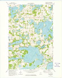
1973 Map of Star Lake
USGS Topo · Published 1975About this map
Glacial geology defines this portion of Otter Tail County, where a dense network of kettle lakes and wetlands dominates the landscape in the early 1970s. The primary focal point is the expansive Star Lake, bordered by several National Waterfowl Production Area parcels, reflecting the region's importance for conservation and habitat. To the north, large water bodies like Big Mc Donald Lake and West Mc Donald Lake are contrasted by smaller, family-named features such as Ottos Lake, Berend Lake, and McCollum Lake. Local history and genealogy are anchored by rural landmarks including the Townhall and several small burial grounds like St Johns Cem and Weimann Community Cem. A patchwork of field lines and gravel extraction sites, including various Gravel Pits, suggests a landscape primarily dedicated to agriculture and local resource management amidst the labyrinth of waterways.
Find a feature on this map
42 named features on this map. Tap any name to fly to it.
Don’t see what you’re looking for? This feature index may not catch every label — zoom into the map to look around manually.
Map Details
Editions of this 1973 Star Lake Map
This is the sole edition of this map. No revisions or reprints were ever made.
Other maps of this area

1912 · Vergas
USGS Topo · 1:62,500

1912 · Battle Lake
USGS Topo · 1:62,500

1914 · Battle Lake
USGS Topo · 1:62,500

1915 · Underwood
USGS Topo · 1:62,500

1915 · Perham
USGS Topo · 1:62,500

1915 · Vergas
USGS Topo · 1:62,500

1953 · Brainerd
USGS Topo · 1:250,000

1957 · Brainerd
USGS Topo · 1:250,000

1958 · Brainerd
USGS Topo · 1:250,000

1965 · Brainerd
USGS Topo · 1:250,000