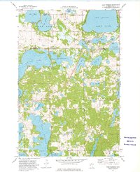
1973 Map of Lake Franklin
USGS Topo · Published 1975About this map
Pelican Lake and Lake Franklin anchor this 1970s landscape on the boundary of Becker and Otter Tail Counties. The map records a glacial lake district defined by its intricate shoreline and heavy woods, where the Pelican River connects Buck Lake to Little Pelican Lake. Rural social life is marked by longstanding religious and community sites including Augustana Church, St Mary of the Lakes Church, and the Lake Eunice Cemetery.
Find a feature on this map
42 named features on this map. Tap any name to fly to it.
Don’t see what you’re looking for? This feature index may not catch every label — zoom into the map to look around manually.
Map Details
Editions of this 1973 Lake Franklin Map
This is the sole edition of this map. No revisions or reprints were ever made.
Other maps of this area

1912 · Vergas
USGS Topo · 1:62,500

1914 · Pelican Rapids
USGS Topo · 1:62,500

1915 · Vergas
USGS Topo · 1:62,500

1917 · Pelican Rapids
USGS Topo · 1:62,500

1953 · Fargo
USGS Topo · 1:250,000

1953 · Brainerd
USGS Topo · 1:250,000

1956 · Fargo
USGS Topo · 1:250,000

1957 · Brainerd
USGS Topo · 1:250,000

1958 · Brainerd
USGS Topo · 1:250,000
1959 · Audubon
USGS Topo · 1:24,000