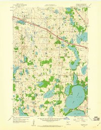
1959 Map of Audubon
USGS Topo · Published 1960About this map
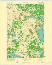
The town of Audubon serves as a central hub in this western Minnesota landscape, situated where the Northern Pacific railroad cuts a diagonal line across the glacial prairie. In the late 1950s, this area was defined by a dense network of water bodies, from the large expanse of Long Lake to smaller basins like Strunk Lake and Audubon Lake. The cultural landscape is marked by long-standing institutions such as Immanuel Cem and the Maple Grove Sch, while newer developments like the Drive-in Theater and the Detroit Lakes Landing Field suggest the post-war shift toward modern transportation and leisure. Further south, the rural character is anchored by the Lake Eunice Ch and a series of interconnected lakes including Pearl Lake and Lake Eunice, illustrating a region where the natural environment and local community infrastructure are tightly integrated.
Find a feature on this map
62 named features on this map. Tap any name to fly to it.
Don’t see what you’re looking for? This feature index may not catch every label — zoom into the map to look around manually.
Map Details
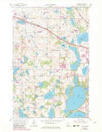
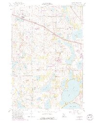
Editions of this 1959 Audubon Map
3 editions found
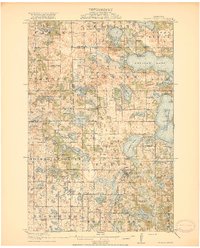
Other maps of this area

1912 · Vergas
USGS Topo · 1:62,500

1914 · Pelican Rapids
USGS Topo · 1:62,500

1915 · Vergas
USGS Topo · 1:62,500
1917 · Pelican Rapids
USGS Topo · 1:62,500

1953 · Fargo
USGS Topo · 1:250,000

1953 · Brainerd
USGS Topo · 1:250,000

1956 · Fargo
USGS Topo · 1:250,000

1957 · Brainerd
USGS Topo · 1:250,000

1958 · Brainerd
USGS Topo · 1:250,000
1959 · Richwood
USGS Topo · 1:24,000