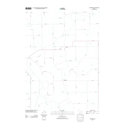
2013 Map of Newbern
USGS Topo · Published 2013About this map
The small settlements of Newbern and Bauer anchor this rural landscape in south-central Iowa, situated along a network of county highways and secondary roads. The terrain is defined by the drainage basins of White Breast Cr and its various tributaries, including Little White Breast Cr, Wolf Cr, and Winn Br. These waterways create a branching hydrographic pattern that dictates the placement of long-standing family farms and the grid of gravel roads like Co Hwy-G62 and Co Hwy-G76. North of these hamlets, the area around Rosemount marks the upper reaches of the map's coverage, where the land transitions between several smaller creek systems such as Flank Cr and Stony Cr. The map captures a quintessential Midwestern agricultural district where the original township structure remains visible through the alignment of numbered avenues and streets.
Find a feature on this map
69 named features on this map. Tap any name to fly to it.
Don’t see what you’re looking for? This feature index may not catch every label — zoom into the map to look around manually.
Map Details
Editions of this 2013 Newbern Map
This is the sole edition of this map. No revisions or reprints were ever made.
Other maps of this area

1909 · Knoxville
USGS Topo · 1:62,500

1910 · Milo
USGS Topo · 1:62,500

1912 · Knoxville
USGS Topo · 1:62,500

1918 · Chariton
USGS Topo · 1:62,500

1924 · Melcher
USGS Topo · 1:62,500

1954 · Des Moines
USGS Topo · 1:250,000

1956 · Des Moines
USGS Topo · 1:250,000

1957 · Des Moines
USGS Topo · 1:250,000

1965 · Milo
USGS Topo · 1:24,000
1965 · Knoxville SW
USGS Topo · 1:24,000
Featured Places
- Melcher-Dallas, IA
- White Breast Township, IA
- Dallas Township, IA
- Franklin Township, IA
- Belmont Township, IA