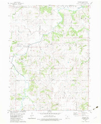
1982 Map of Newbern
USGS Topo · Published 1983About this map
The agrarian landscape of the White Breast Creek valley dominates this region where Marion, Warren, and Lucas counties meet. The settlement of Newbern serves as a local focal point near the southern county line, while the community of Bauer sits further north, anchored by St Josephs Ch. The map reveals a high density of rural burial grounds, including St Paul Cem, Tickel Cem, and Spring Hill Cem, reflecting the deep-rooted family history of these townships. Drainage patterns are defined by the winding course of Wolf Creek and Little White Breast Creek, which carve through the terrain of Dallas and English townships. Small-scale industrial activity is evident at the Quarries located east of Winn Branch, while the Gaging Station on the creek provides a technical detail of the era's water management.
Find a feature on this map
41 named features on this map. Tap any name to fly to it.
Don’t see what you’re looking for? This feature index may not catch every label — zoom into the map to look around manually.
Map Details
Editions of this 1982 Newbern Map
This is the sole edition of this map. No revisions or reprints were ever made.
Other maps of this area

1909 · Knoxville
USGS Topo · 1:62,500

1910 · Milo
USGS Topo · 1:62,500

1912 · Knoxville
USGS Topo · 1:62,500

1918 · Chariton
USGS Topo · 1:62,500

1924 · Melcher
USGS Topo · 1:62,500

1954 · Des Moines
USGS Topo · 1:250,000

1956 · Des Moines
USGS Topo · 1:250,000

1957 · Des Moines
USGS Topo · 1:250,000

1965 · Milo
USGS Topo · 1:24,000
1965 · Knoxville SW
USGS Topo · 1:24,000