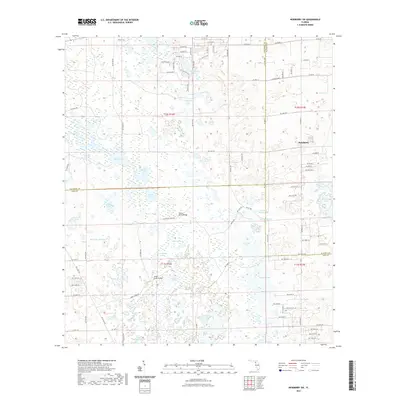
2021 Map of Newberry SW
USGS Topo · Published 2021About this map
Newberry sits at the northeastern edge of a landscape defined by an intricate network of karst wetlands and shifting water bodies along the borders of Alachua, Gilchrist, and Levy counties. This modern topographic survey illustrates how the limestone-rich terrain creates a mosaic of isolated ponds and lakes, such as Shirley Lake, Watermelon Pond, and the curiously named Doorshutter Lake. The hydrology of the area is further characterized by Sawgrass Springs and the headwaters of the Waccasassa River, which meanders through the southwestern section. Transport and crossing points remain vital to the local geography, evidenced by named landmarks like the Porter Smith Bridge and Asbell Creek Bridge. The map details a transition from the structured street grids of the settlement into the winding rural routes like Asbell Creek Rd and NE Waters Pond Rd, reflecting the region's enduring character as a blend of small-town life and North Central Florida wilderness.
Find a feature on this map
79 named features on this map. Tap any name to fly to it.
Don’t see what you’re looking for? This feature index may not catch every label — zoom into the map to look around manually.
Map Details
Editions of this 2021 Newberry SW Map
This is the sole edition of this map. No revisions or reprints were ever made.
Other maps of this area

1954 · Chiefland
USGS Topo · 1:24,000

1954 · Bronson
USGS Topo · 1:24,000

1954 · Gainesville
USGS Topo · 1:250,000

1955 · Bronson NE
USGS Topo · 1:24,000

1958 · Gainesville
USGS Topo · 1:250,000

1959 · Gainesville
USGS Topo · 1:250,000

1968 · Newberry SW
USGS Topo · 1:24,000

1968 · Waters Lake
USGS Topo · 1:24,000
1968 · Archer
USGS Topo · 1:24,000

1968 · Newberry
USGS Topo · 1:24,000