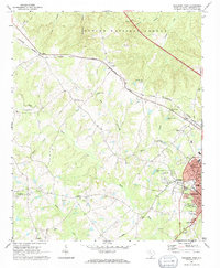
1969 Map of Newberry West
USGS Topo · Published 1973About this map
Newberry serves as the focal point of this 1960s landscape, where the municipal limits reach westward toward the industrial and residential hub of Helena. The area is defined by a dense network of country churches and community centers that served the rural population, including St James Ch near Jalapa and the Bush River Community Center further south. The transportation infrastructure of the era is clearly marked by the dual presence of the Southern and Columbia Newberry and Laurens railroads, which facilitated movement across the Piedmont terrain.
Find a feature on this map
45 named features on this map. Tap any name to fly to it.
Don’t see what you’re looking for? This feature index may not catch every label — zoom into the map to look around manually.
Map Details
Editions of this 1969 Newberry West Map
2 editions found
Other maps of this area

1941 · Spartanburg
USGS Topo · 1:250,000

1953 · Spartanburg
USGS Topo · 1:250,000

1960 · Spartanburg
USGS Topo · 1:250,000

1963 · Spartanburg
USGS Topo · 1:250,000

1964 · Spartanburg
USGS Topo · 1:250,000

1968 · Newberry East
USGS Topo · 1:24,000

1969 · Whitmire South
USGS Topo · 1:24,000

1969 · Newberry NW
USGS Topo · 1:24,000

1969 · Newberry West
USGS Topo · 1:24,000
1970 · Prosperity
USGS Topo · 1:24,000