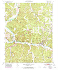
1950 Map of Newburg
USGS Topo · Published 1977About this map
The Gasconade River and Little Piney Creek converge in this mid-century Missouri landscape, framing the central hubs of Newburg and Arlington. The industrial and transport backbone of the region is defined by the St Louis San Francisco railroad, which follows the river valleys and services the local timber and farming communities. This survey reveals a land transition from deep river bottoms to the heights of Pea Ridge and the Devils Backbone, much of which is contained within the Mark Twain National Forest. Local life is anchored at rural landmarks like New Home Ch and Mungy Sch, while the presence of the Boulware Ford (Abandoned) and Whitehouse Ford (Abandoned) indicates a shift away from traditional river crossings toward modern roadway infrastructure. Factual details such as the Gaging Station and various hollows like Sugartree Hollow provide specific points of interest for historical study.
Find a feature on this map
49 named features on this map. Tap any name to fly to it.
Don’t see what you’re looking for? This feature index may not catch every label — zoom into the map to look around manually.
Map Details
Editions of this 1950 Newburg Map
4 editions found

Other maps of this area

1888 · Tuscumbia
USGS Topo · 1:125,000

1894 · Tuscumbia
USGS Topo · 1:125,000

1912 · Rolla
USGS Topo · 1:62,500

1936 · Waynesville
USGS Topo · 1:48,000

1937 · Vienna
USGS Topo · 1:62,500

1938 · Vienna
USGS Topo · 1:48,000

1942 · Waynesville
USGS Topo · 1:62,500

1944 · Waynesville
USGS Topo · 1:62,500

1947 · Jefferson City
USGS Topo · 1:250,000

1948 · Tavern
USGS Topo · 1:62,500