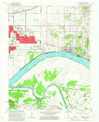
1964 Map of Newburgh
USGS Topo · Published 1966About this map
Angel Mounds State Memorial and the sprawling ancient earthworks of the Indian Mounds anchor the bend of the Ohio River east of Evansville. This mid-1960s landscape transition shows the steady suburban expansion of Knight township, where the Lawndale Shopping Center and Washington Square Shopping Center mark the commercial edge of the city. To the east, the town of Newburgh overlooks Threemile Island and the critical maritime infrastructure at Lock and Dam No 47. Across the river in Kentucky, the terrain shifts to the dense network of the Green River and the Cypress Slough, characterized by river-driven drainage like the Griffith Slough Ditch. The presence of the Louisville and Nashville railroad and rural landmarks such as Sloans Chapel and Baskett Cem illustrate the enduring agricultural and industrial roots that defined the Indiana-Kentucky borderlands during this era.
Find a feature on this map
63 named features on this map. Tap any name to fly to it.
Don’t see what you’re looking for? This feature index may not catch every label — zoom into the map to look around manually.
Map Details
Editions of this 1964 Newburgh Map
Other maps of this area

1901 · Haubstadt
USGS Topo · 1:62,500

1902 · Ditney
USGS Topo · 1:125,000

1902 · Boonville
USGS Topo · 1:62,500

1903 · Haubstadt
USGS Topo · 1:62,500

1903 · Patoka
USGS Topo · 1:125,000

1905 · Newburg
USGS Topo · 1:62,500

1914 · Henderson
USGS Topo · 1:48,000

1916 · Henderson
USGS Topo · 1:62,500

1951 · Yankeetown
USGS Topo · 1:24,000

1951 · Spottsville
USGS Topo · 1:24,000