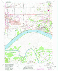
1964 Map of Newburgh
USGS Topo · Published 1981About this map
The archaeological significance of Angel Mounds State Memorial anchors this stretch of the Ohio River, where the borders of Indiana and Kentucky meet amidst a network of drainage canals like Edwards Ditch and Howard DITCH. On the Indiana side, the expansion of Evansville is evident in the mid-century commercial footprints of the Lawndale Shopping Center and Washington Square Shopping Center. Further east, the riverfront town of Newburgh sits perched above the water, flanked by several family and community burial grounds including Rose Hill Cem and Casey Cem. Across the river, the landscape shifts to the winding curves of the Green River and the lowlands of Cypress Slough, illustrating the stark contrast between the developing suburban uplands and the river-bottom wetlands. The presence of the Southern and Louisville and Nashville railroads underscores the area's role as a transportation corridor.
Find a feature on this map
64 named features on this map. Tap any name to fly to it.
Don’t see what you’re looking for? This feature index may not catch every label — zoom into the map to look around manually.
Map Details
Editions of this 1964 Newburgh Map
Other maps of this area

1901 · Haubstadt
USGS Topo · 1:62,500

1902 · Ditney
USGS Topo · 1:125,000

1902 · Boonville
USGS Topo · 1:62,500

1903 · Haubstadt
USGS Topo · 1:62,500

1903 · Patoka
USGS Topo · 1:125,000

1905 · Newburg
USGS Topo · 1:62,500

1914 · Henderson
USGS Topo · 1:48,000

1916 · Henderson
USGS Topo · 1:62,500

1951 · Yankeetown
USGS Topo · 1:24,000

1951 · Spottsville
USGS Topo · 1:24,000