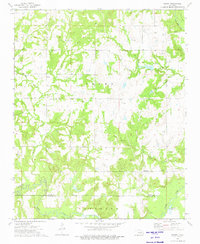
1973 Map of Newby
USGS Topo · Published 1975About this map
The Newby Oil Field defines the industrial character of this central Oklahoma landscape during the early 1970s. Located along the border of Creek Co and Okfuskee Co, the area is densely marked by Oil Wells and extractive infrastructure. The settlement of Newby serves as a local hub near Sandy Creek, while the community of Tuskegee sits further south near its namesake Tuskegee Cem.
Find a feature on this map
19 named features on this map. Tap any name to fly to it.
Don’t see what you’re looking for? This feature index may not catch every label — zoom into the map to look around manually.
Map Details
Editions of this 1973 Newby Map
This is the sole edition of this map. No revisions or reprints were ever made.
Other maps of this area

1901 · Nuyaka
USGS Topo · 1:125,000

1914 · Kiefer
USGS Topo · 1:62,500

1916 · Kiefer
USGS Topo · 1:62,500

1916 · Bristow
USGS Topo · 1:62,500

1954 · Oklahoma City
USGS Topo · 1:250,000

1957 · Oklahoma City
USGS Topo · 1:250,000

1963 · Oklahoma City
USGS Topo · 1:250,000
1973 · Nuyaka
USGS Topo · 1:24,000
1973 · Slick
USGS Topo · 1:24,000
1973 · Okfuskee
USGS Topo · 1:24,000