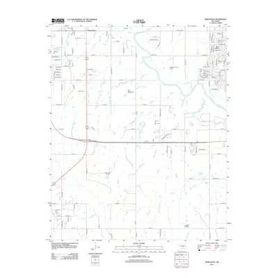
2013 Map of Newcastle
USGS Topo · Published 2013About this map
The Canadian River snakes through this Central Oklahoma landscape, defining the eastern edges of Newcastle. The settlement pattern reflects a mix of suburban expansion and traditional resource extraction, with the town center giving way to a grid of rural roads and residential enclaves like those near Mount Williams. Significant energy infrastructure is evident in the numerous petroleum deposits mapped across the area, including the Southeast Newcastle Oil Field, North Lindsay Ridge Oil Field, and North Freeny Oil Field. These fields suggest a long-standing economic reliance on the subsurface mineral wealth of the region. Local history is further grounded in sites like Warren Cem, while the drainage network of Pond Cr, Marcy Cr, and Boggy Cr illustrates the hydrology of the plains. This era of the city's history shows a community transitioning from its oil-field roots into a modern residential hub south of the state capital.
Find a feature on this map
126 named features on this map. Tap any name to fly to it.
Don’t see what you’re looking for? This feature index may not catch every label — zoom into the map to look around manually.
Map Details
Editions of this 2013 Newcastle Map
This is the sole edition of this map. No revisions or reprints were ever made.
Other maps of this area

1892 · Moore
USGS Topo · 1:62,500

1893 · Norman
USGS Topo · 1:62,500

1893 · Oklahoma City
USGS Topo · 1:62,500

1898 · Purcell
USGS Topo · 1:125,000

1904 · Chickasha
USGS Topo · 1:125,000

1925 · Norman NO 2
USGS Topo · 1:24,000

1934 · Moore
USGS Topo · 1:62,500

1936 · Norman
USGS Topo · 1:62,500

1938 · Moore
USGS Topo · 1:62,500

1954 · Oklahoma City
USGS Topo · 1:250,000