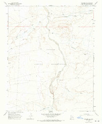
1966 Map of Newcomb SE
USGS Topo · Published 1969About this map
The Navajo Indian Reservation landscape in the mid-1960s is defined by a dendritic network of ephemeral drainage systems converging toward the Chaco River. This arid terrain in San Juan County is marked by significant washes that speak to the region's hydrography, including the prominent Captain Tom Wash and Brimhall Wash to the north. The presence of a solitary Landing Strip in the northeast and scattered Well locations suggests a landscape of sparse infrastructure, where travel and resource extraction were tied to specific, localized points in the high desert. To the south, Teec-ni-di-tso Wash, Hunter Wash, and Sheep Springs Wash further illustrate the intricate erosion patterns and topographical complexity of this part of the Colorado Plateau.
Find a feature on this map
9 named features on this map. Tap any name to fly to it.
Don’t see what you’re looking for? This feature index may not catch every label — zoom into the map to look around manually.
Map Details
Editions of this 1966 Newcomb SE Map
2 editions found
Other maps of this area

1889 · Chaco
USGS Topo · 1:250,000

1892 · Chaco
USGS Topo · 1:250,000

1927 · Sulphur Spring
USGS Topo · 1:96,000

1928 · Kirtland
USGS Topo · 1:125,000

1932 · Kirtland
USGS Topo · 1:125,000

1954 · Shiprock
USGS Topo · 1:250,000

1958 · Shiprock
USGS Topo · 1:250,000

1959 · Shiprock
USGS Topo · 1:250,000
1966 · Sheep Springs
USGS Topo · 1:24,000
1966 · Newcomb NE
USGS Topo · 1:24,000