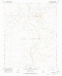
1966 Map of Newcomb SE
USGS Topo · Published 1978About this map
The Chaco River carves a central path through this section of the Navajo Indian Reservation, defining a landscape of complex drainage systems in the high desert of New Mexico. Surveyed in the mid-1960s, the map reveals an intricate network of seasonal watercourses, including Brimhall Wash, Captain Tom Wash, and the phonetically distinct Teec-ni-di-tso Wash. The terrain is characterized by these sprawling washes and deep arroyos that feed into the main river channel from both the east and west.
Find a feature on this map
9 named features on this map. Tap any name to fly to it.
Don’t see what you’re looking for? This feature index may not catch every label — zoom into the map to look around manually.
Map Details
Editions of this 1966 Newcomb SE Map
2 editions found
Other maps of this area

1889 · Chaco
USGS Topo · 1:250,000

1892 · Chaco
USGS Topo · 1:250,000

1927 · Sulphur Spring
USGS Topo · 1:96,000

1928 · Kirtland
USGS Topo · 1:125,000

1932 · Kirtland
USGS Topo · 1:125,000

1954 · Shiprock
USGS Topo · 1:250,000

1958 · Shiprock
USGS Topo · 1:250,000

1959 · Shiprock
USGS Topo · 1:250,000
1966 · Sheep Springs
USGS Topo · 1:24,000
1966 · Newcomb NE
USGS Topo · 1:24,000