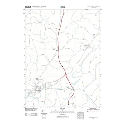
2010 Map of Newcomerstown
USGS Topo · Published 2010About this map
The Tuscarawas River carves a broad valley through this portion of Tuscarawas County, dictating the development of settlements and transportation. Newcomerstown serves as a primary hub, containing several notable burial grounds such as State Street Cemetery and South Bridge Cemetery, along with the Newcomerstown Post Office. To the northeast, the village of Port Washington sits near the Union Cemeteries, while the landscape is dotted with smaller communities like Wolf, Glasgow, and Coalport. The influence of the river is evident in place names such as Stark Patent Bottom and Nugent Bottom, reflecting the importance of the alluvial flats for early settlement. High ground is marked by distinctive landmarks including Umbrella Rock and Elephant Knob, while local aviation is served by Foraker Airport.
Find a feature on this map
94 named features on this map. Tap any name to fly to it.
Don’t see what you’re looking for? This feature index may not catch every label — zoom into the map to look around manually.
Map Details
Editions of this 2010 Newcomerstown Map
This is the sole edition of this map. No revisions or reprints were ever made.
Other maps of this area

1909 · Antrim
USGS Topo · 1:48,000

1909 · Uhrichsville
USGS Topo · 1:62,500

1909 · Cambridge
USGS Topo · 1:62,500

1911 · Antrim
USGS Topo · 1:62,500

1911 · Uhrichsville
USGS Topo · 1:62,500

1911 · Newcomerstown
USGS Topo · 1:62,500

1912 · Cambridge
USGS Topo · 1:62,500

1913 · Newcomerstown
USGS Topo · 1:62,500

1943 · Newcomerstown
USGS Topo · 1:62,500

1951 · Canton
USGS Topo · 1:250,000