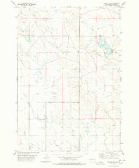
1977 Map of Newell Lake
USGS Topo · Published 1978About this map
Newell Lake serves as a focal point in this 1970s landscape of Butte County, where the transition between natural watercourses and engineered irrigation is clearly visible. The terrain is defined by several intermittent streams, including Butte Creek and Dry Creek, which give way to an extensive network of water management features in the southern portion of the quadrangle. This sophisticated irrigation system, essential for agriculture in western South Dakota, is mapped in detail through the North Canal and various named branches such as the Coyote Lateral, Deadman Lateral, and Town Site Lateral. The presence of the Picnic Area near the lake's eastern shore indicates the dual-purpose nature of the reservoir for both utility and local recreation. For researchers of the region's hydraulic history, the map provides a precise layout of how the North Canal feeds into secondary channels like the Deer Creek Lateral.
Find a feature on this map
17 named features on this map. Tap any name to fly to it.
Don’t see what you’re looking for? This feature index may not catch every label — zoom into the map to look around manually.
Map Details
Editions of this 1977 Newell Lake Map
This is the sole edition of this map. No revisions or reprints were ever made.
Other maps of this area

1905 · Saint Onge
USGS Topo · 1:62,500

1906 · Two Top
USGS Topo · 1:62,500

1906 · Vale
USGS Topo · 1:62,500

1907 · Belle Fourche
USGS Topo · 1:125,000

1913 · Newell
USGS Topo · 1:125,000

1951 · Newell
USGS Topo · 1:24,000

1951 · Vale NE
USGS Topo · 1:24,000
1951 · Nisland
USGS Topo · 1:24,000

1951 · Vale
USGS Topo · 1:62,500

1953 · Rapid City
USGS Topo · 1:250,000