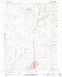
1968 Map of Newkirk
USGS Topo · Published 1991About this map
The Chilocco Indian School and its extensive campus of reservoirs, cemeteries, and agricultural fields dominate the landscape just south of the Kansas-Oklahoma state line. This 1968 study captures the region's complex infrastructure, where the Atchison Topeka and Santa Fe and St Louis San Francisco railroads intersect the rolling prairie. Further south, the town of Newkirk serves as a prominent hub, centered around its Courthouse, High School, and the Home for the Aged. The drainage patterns of Bois d' Arc Creek and Chilocco Creek define the rural stretches between these settlements, revealing a land defined by early educational institutions and long-established rail corridors. Smaller settlements like Middleton and local landmarks such as St Francis Sch provide finer points of interest for genealogists tracing family roots in northern Kay County.
Find a feature on this map
28 named features on this map. Tap any name to fly to it.
Don’t see what you’re looking for? This feature index may not catch every label — zoom into the map to look around manually.
Map Details
Editions of this 1968 Newkirk Map
2 editions found
Other maps of this area

1889 · Burden
USGS Topo · 1:125,000

1890 · Wellington
USGS Topo · 1:125,000

1935 · Kaw
USGS Topo · 1:62,500

1955 · Wichita
USGS Topo · 1:250,000

1955 · Enid
USGS Topo · 1:250,000

1958 · Enid
USGS Topo · 1:250,000

1958 · Wichita
USGS Topo · 1:250,000

1963 · Uncas
USGS Topo · 1:24,000

1963 · Kaw City NW
USGS Topo · 1:24,000

1965 · Silverdale
USGS Topo · 1:24,000