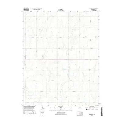
2016 Map of Newkirk SW
USGS Topo · Published 2016About this map
Grainville anchors this Kay County landscape, situated amidst a precise grid of rural roads and north-south section lines that define the agricultural character of north-central Oklahoma. The terrain is marked by a series of south-flowing drainages, including Lost Cr, Duck Cr, and the forks of W Cattle Cr and E Cattle Cr, which carve gentle relief into the prairie. This 2016 survey illustrates the persistent importance of local landmarks for genealogy and local history, specifically the distribution of rural burial grounds such as Saint Johns Cem and Prairie Chapel Cem. The inclusion of the Indian Meridian TL highlights the historical surveying foundations of the region, while the Lost Duck Creeks Site D-1 Reservoir demonstrates modern water management within this traditional farming and ranching corridor.
Find a feature on this map
39 named features on this map. Tap any name to fly to it.
Don’t see what you’re looking for? This feature index may not catch every label — zoom into the map to look around manually.
Map Details
Editions of this 2016 Newkirk SW Map
This is the sole edition of this map. No revisions or reprints were ever made.
Other maps of this area

1955 · Enid
USGS Topo · 1:250,000

1958 · Enid
USGS Topo · 1:250,000

1967 · Braman
USGS Topo · 1:24,000

1968 · Ponca City NW
USGS Topo · 1:24,000
1968 · Newkirk
USGS Topo · 1:24,000

1968 · Tonkawa
USGS Topo · 1:24,000

1968 · Kildare
USGS Topo · 1:24,000

1968 · Blackwell
USGS Topo · 1:24,000
1968 · Newkirk SW
USGS Topo · 1:24,000
1968 · Peckham
USGS Topo · 1:24,000