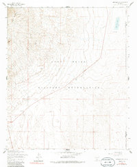
1955 Map of Newman NW
USGS Topo · Published 1986About this map
The Fort Bliss Military Reservation occupies a massive footprint across this desert landscape, where the high desert floor meets the base of the Organ Mountains to the west. This mid-1950s survey reflects an era of intense military activity and early aviation, marked by the presence of Airway Beacon 9 and a standalone Tower positioned south of the reservation line. The terrain is defined by dry lake beds and catchment basins, including Old Coe Lake, and a series of livestock tanks like Scott Tank and Pit Tank that supported ranching operations even as military use expanded. High points such as Deer Hill and the Black Hills rise above the transition zone between the mountains and the low-lying basins of the Dona Ana Co Otero Co boundary.
Find a feature on this map
11 named features on this map. Tap any name to fly to it.
Don’t see what you’re looking for? This feature index may not catch every label — zoom into the map to look around manually.
Map Details
Editions of this 1955 Newman NW Map
3 editions found
Other maps of this area

1891 · Las Cruces
USGS Topo · 1:125,000

1893 · Las Cruces
USGS Topo · 1:125,000

1940 · Newman
USGS Topo · 1:62,500

1941 · Organ Peak
USGS Topo · 1:62,500

1943 · La Mesa
USGS Topo · 1:62,500

1943 · Parker Lake
USGS Topo · 1:62,500

1943 · Newman
USGS Topo · 1:62,500

1943 · Organ Peak
USGS Topo · 1:62,500

1948 · Davies Tank
USGS Topo · 1:24,000

1948 · Newman NW
USGS Topo · 1:24,000