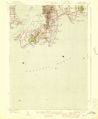
1944 Map of Newport
USGS Topo · Published 1944About this map
Newport and Middletown define this coastal landscape at the height of the World War II era, showing a community structured by its maritime defense and Gilded Age heritage. The map details the strategic military presence at Fort Adams and Fort Wetherill guarding the East Passage of Narragansett Bay. Inland, the density of the city grid contrasts with the sprawling estates along Bellevue Ave and the southern peninsula, where the famous Cliff Walk traces the rocky shoreline between Ochre Pt and Rough Pt. Notable educational and social landmarks like De La Salle Academy, St Georges Sch, and the Newport Country Club reflect the established social fabric of the period. Coastal features such as Purgatory, Forty Steps, and Spouting Rock offer specific points of interest for those studying the natural and cultural geography of the Rhode Island coast.
Find a feature on this map
80 named features on this map. Tap any name to fly to it.
Don’t see what you’re looking for? This feature index may not catch every label — zoom into the map to look around manually.
Map Details
Editions of this 1944 Newport Map
3 editions found
Other maps of this area

1885 · Sakonnet
USGS Topo · 1:62,500

1888 · Fall River
USGS Topo · 1:62,500

1888 · Sakonnet
USGS Topo · 1:62,500

1889 · Newport
USGS Topo · 1:62,500

1890 · Narragansett Bay
USGS Topo · 1:62,500

1892 · Narragansett Bay
USGS Topo · 1:62,500

1893 · Sakonnet
USGS Topo · 1:62,500

1893 · Fall River
USGS Topo · 1:62,500

1894 · Newport
USGS Topo · 1:62,500

1904 · Newport
USGS Topo · 1:62,500